• 1
  • 2
  • 3
  • 4

Activities

  • NITOS Outdoor deployment consists of powerful nodes that feature multiple wireless interfaces and allow for experimentation with heterogeneous (Wi-Fi, WiMAX,

    Read More
  • The setup NITOS testbed is currently using is a fixed setup (employing no mobility between BSs) that does not require

    Read More
  • Towards the development of a remote accessible LTE testbed, where experimenters from all the word will be able to run

    Read More
  • NITOS facility provides remote access to OpenFlow switches (2 x Pronto 3290 , 2 x HP 3800 ), enabling the user to create

    Read More
  • NITlab developed a software defined radio (SDR) testbed that consists of 18 Universal Software Radio Peripheral (USRP) devices attached to

    Read More
  • NITOS is an Intelligent Transport System (ITS) compatible facility thanks to the implementation of the key components of the ITS

    Read More
  • NITOS cloud infrastructure is based on HP GEN8 blade servers and one HP DL380p GEN8 server. Cloud Infrastructure UTH 
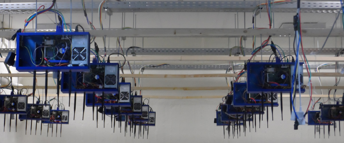
Each blade server has

    Read More

NITOS

The Future Internet Facility

  • Outdoor Testbed

    Experiments under real world environment Read More
  • Indoor Testbed

    Experiments in RF isolated environment Read More
  • Office testbed

    Experiments in an office environment Read More
  • 1
  • 2
  • 3

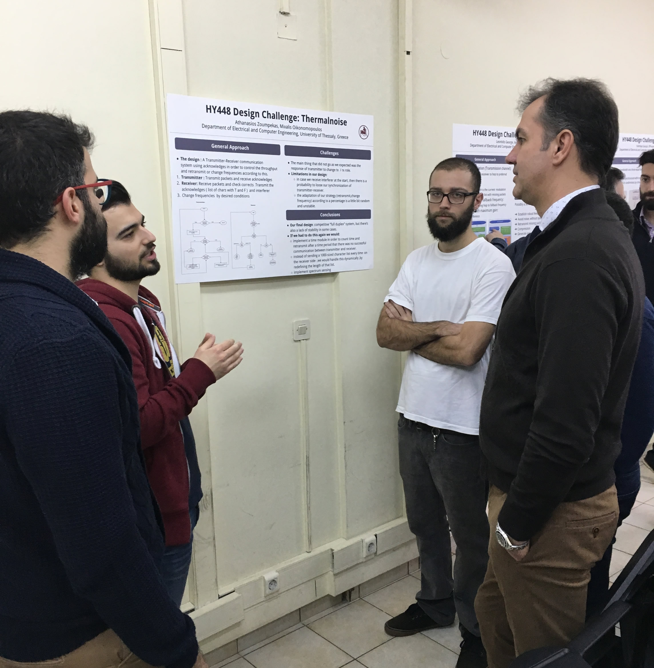
NITOS Mobile Sensing Testbed: Experimenting with Android Sensing Devices in a City-Wide Environment

In this demo we present a mobile testbed equipped with sensing devices attached to smartphones of volunteer users broadening the smartphone’s sensing capabilities by adding external environmental sensors. The provided hardware allows for realization of complex experimental scenarios involving participatory and crowd-sensing applications. For this purpose we also extended the OMF framework used on NITOS to support experimentation with the new mobile testbed resources and ease the workflow of experimentation-driven research.

Mobile Sensing Testbed

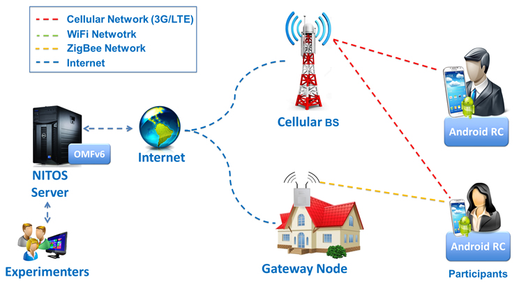
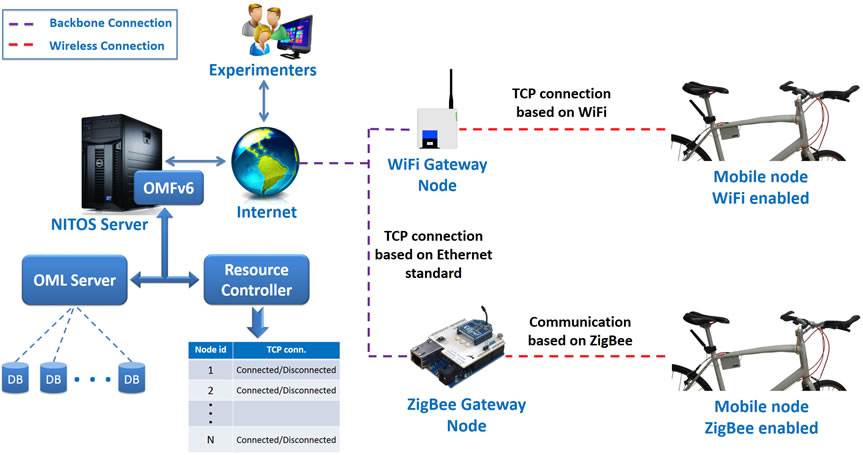
Figure 1: Mobile Sensing Testbed Architecture

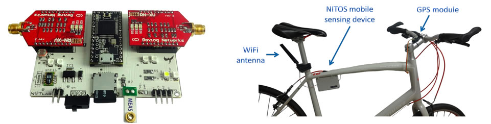
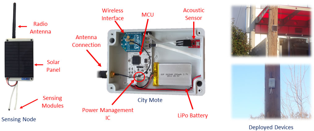
To augment the sensing capabilities of commercial smartphones we developed a small-sized, low-cost embedded device that can be interfaced with external sensors and can feed the collected measurements into Android platforms through a USB connection. Due to its low profile it can be placed beneath the back cover of conventional smartphones, as illustrated in Figure 2, while being powered by the smartphone's supply through the same USB connection.

Sensing Device

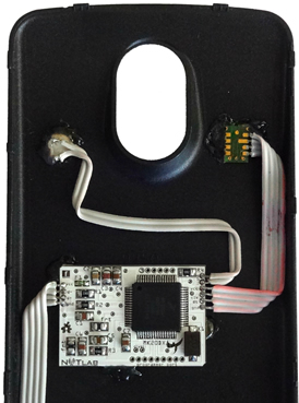
 Figure 2: Developed Sensing Device Deployed Beneath the back cover of a Smart-phone

Our prototype device is based on Arduino-like modules since Arduino follows an open approach, providing a vast number of software libraries and hardware modules.

The device features a 32-bit ARM microprocessor with 128KB of flash and 2KB of EEPROM memory. It hosts several I/O pins, 3 UART ports and one SPI bus. It operates at 3.3V, while supporting a dynamic core frequency scaling up to 96 MHz. Currently, our implementation integrates the sht11 temperature & humidity module, and a light-intensity sensor, all placed on the smartphone's back cover. The device operates at 3.3V, produced by the internal ARM's regulator, which also provides up to 100mA to the rest of the peripherals. Thus, we didn't place any external regulator, as that would result in a higher power consumption. Moreover, in order to activate communication with the host Android, we used a serial bus at 9600 baud rate realized over the USB connection. The firmware on the microprocessor is responsible for the entire device's operation. Briefly, the microprocessor gathers data from the sensors and logs them locally on its EEPROM. In turn, the data are forwarded to the host smartphone whenever requested by the Android application. Between each measurement cycle, the microprocessor saves energy by setting itself and the rest peripherals in deep sleep mode. They are awakened by an internal timer that can be configured to fire after up to 65 seconds. Our firmware is custom developed, written in Arduino language and flashed into the device through the teensy loader. Notably, the device can be further extended to support additional sensing modules, broadening its scope of environmental monitoring.

Android Application

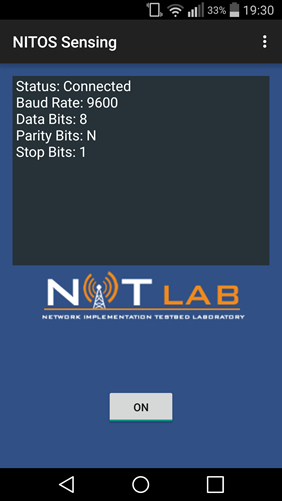
Figure 3: Developed Android Application

Regarding the remote control of Android smartphones, a dedicated Resource Controller (RC) has been developed so that experimenters could launch any application they desire or configure the phone according to their needs, through experiment descriptions provided to the EC. The RC is capable of dealing with intermittent connectivity when users are not in range of a WiFi AP and the connection between the EC and RC is lost. The supported actions of the RC include starting/stopping another Android application, configuring the WiFi interface of the phone and executing Android shell commands. The RC application runs as a background service, which does not hinder the normal usage of the phone by the volunteers during the day. An accompanying application which was developed for the purposes of acquiring measurements from the phone is provided to the experimenters of the NITOS testbed. The purpose of this application is to communicate with the external device attached to the phone, which features various environmental sensors. In more detail, a serial communication is established with the external device through the USB port of the phone and requests for measurements are sent to the device which returns the results back to the application. For implementing the serial communication over the USB port of the phone, the corresponding Android library has been used. The App interacts with the RC in order to offload the gathered measurements to a database with the aid of OML. During periods of connectivity disruptions, the measurements are cached until the connection is restored.

In the matter of the smartphone sensing device, we observed that it requires approximately 320 ms to awake and perform a full measurement cycle (mainly due to the long time required to acquire measurements from the sht11 module). Based on this finding and also considering an experiment with a sensing interval of 1 minute, we estimated that the device consumes approximately 2.67 mAh from the smartphone's battery per day.

Google Map

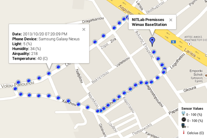
Figure 4: Developed Android Application

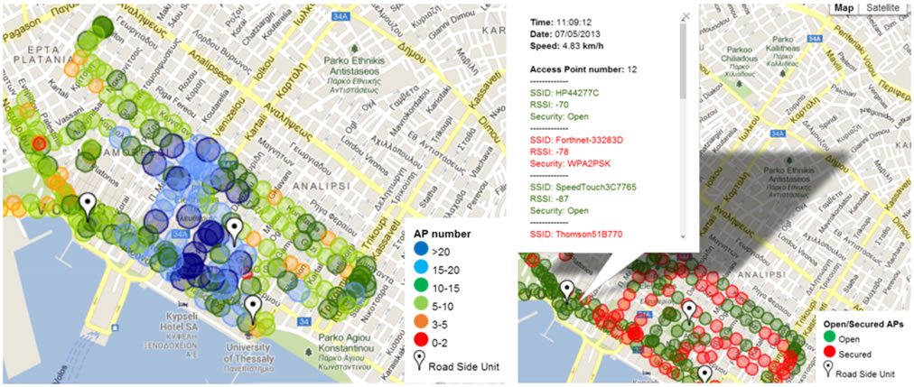
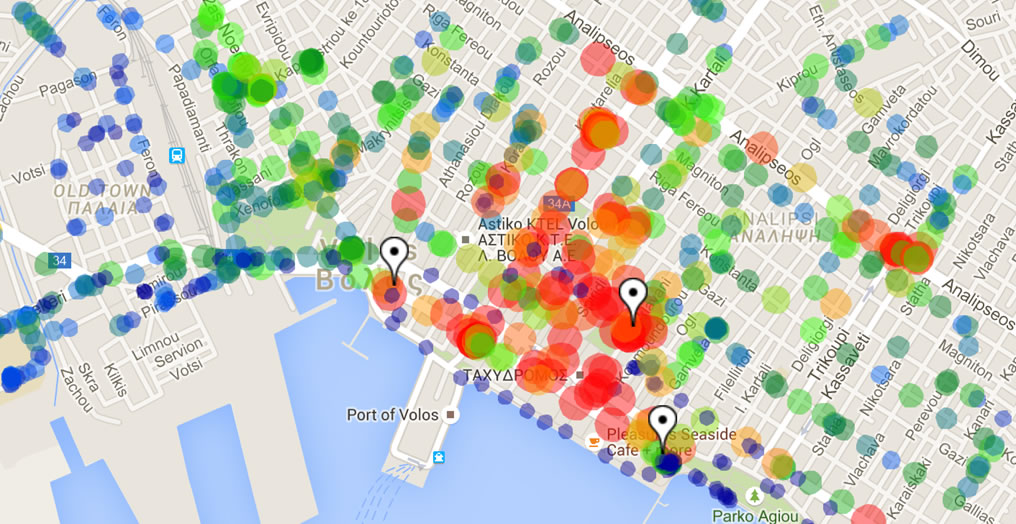
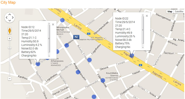
All the acquired data are available to the user and can be depicted on Google maps, using the Google Maps API. Figure 4 shows an indicative experiment conducted around NITlab premises in Volos, Greece.

Related paper

You can also download the relevant paper accepted in EuCNC 2015:

Gathering_environmental_measurements_EuCNC

Demonstration 

NITOS BikesNet

NITOS BikesNet is a remotely controlled city-scale mobile sensing framework based on the bicycles of volunteer users. NITOS BikesNet employs an open-source embedded sensing device that can be easily mounted on a bicycle, enabling the automatic collection of environmental and WiFi measurements in different parts of the city. In addition, the NITOS platform features a unified way for controlling the sensing devices and collecting their measurements via OMF/OML in combination with opportunistic and delay-tolerant networking methods.

NITlab have developed a prototype sensing device based on open-source and configurable modules.  The core module is an open-source development board (teensy 3.0), fully compatible with Arduino software that integrates a 32-bit ARM microprocessor running at 48MHz. The microprocessor communicates with several sensors and modules through a custom-made board. An air temperature and humidity sensor is integrated as well as a photo-resistor that reports the light intensity. Moreover, an Arduino compatible WiFi interface is utilized, configured to operate in monitor mode, so as to collect available WiFi network's statistics, such as SSID names, Received Signal Strength (RSS), as well as the encryption supported from each captured network. Exploiting the aforementioned modules, the developed device senses periodically the existing environmental conditions and networks, as the vehicle is moving around the city. In addition, the device is equipped with a GPS Receiver, which is a small-sized module compatible with Arduino software. This module provides the coordinates of the vehicle, thus enabling for localization of the acquired measurements. Additionally, it reports the exact time and date each measurement has been obtained. The extracted measurements along with their coordinates and time-stamp, are locally logged in the available micro SD card. Furthermore, the developed device is equipped with a second wireless interface that can be either a WiFi or a ZigBee module in order to wirelessly communicate with any available gateway node. Figure 1 illustrates the developed sensing device as well as its installation on a bicycle.

 NITOS Sensing Device

Figure 1: NITOS Sensing Device & its Installation on a Bicycle

The control and management of the mobile resources during the experiment is handled by the OMF framework and the measurement collection is being facilitated with the OMF Measurement Library (OML). More specifically, we extended the existing OMF framework in order to meet our needs for managing an enhanced testbed, which features mobile sensors attached on bikes. The developed prototype can sense and cache the obtained measurements until it is located inside the coverage area of statically located gateway nodes, in order to upload the perceived measurements. Moreover, the delay tolerance of our framework is not met only in the part of measurement caching and collection, but also in the part of experiment orchestration. The commands intended for the mobile sensors are being deferred when connectivity with the corresponding sensors is lost and transmitted as soon as the connection is reestablished. Figure 2 illustrates the architecture of the developed city-wide mobile sensing framework. 

Bikesnet Architecture

Figure 2: NITOS BikesNet Architecture

NITlab also developed a set of tools that enable the experimenters not only to depict the raw collected data, but to perform further actions like filtering and aggregating the several measurement points. To visualize and analyze the obtained results in a flexible way, we developed a web-based tool based on Google Maps API. We present indicative results obtained from some first city-scale experiments performed in Volos city in Figure 3.

NITOS Bikesnet: City of Volos Map

Figure 3: Number of Obtained WiFi Networks in the City of Volos & Open/Secured WiFi Networks

 NITOS Bikesnet: City of Volos Map

NITOS City Sensing Deployment

Based on the NITOS prototype mote, NITlab have deployed a pilot Wireless Sensor Network (WSN) in the city of Volos. The NITOS mote has been enclosed in a water-proof box, equipped with external sensors, radio antenna and a solar panel. Sensors measures the air temperature & humidity, as well as light intensity and noise pollution. Temperature, humidity and light sensors are deployed out of the enclosure via waterproof wires, to avoid any interference with node’s internal conditions. Whilst, the microphone is in the box, sensing noise pollution through a tiny hole. The nodes are autonomous in terms of power, harvesting energy via their solar panels charging their LiPo battery via an integrated circuit. The deployed nodes create a mesh network topology over the IEEE802.15.4 protocol. To realize this, we exploited the XBee S1 wireless interfaces configured to run the Digimesh firmware. Digimesh offers network stability through self-healing, self-discovery, and dense network operation. With support for sleeping routers, DigiMesh is ideal for power sensitive applications relying upon batteries or power harvesting technology for power. Exploiting Digimesh all nodes are set up in duty-cycle operation. This means a node is configured to operate in low-power state (sleep mode) and to wake up when it can expect a message from a neighbor node. This works through very precise synchronization of the transmitting and receiving nodes. As a result, the routing nodes will also be in a nearly powerless sleeping state most of the time, achieving ultra-low-power operation. The more accurately the wake-up schedule can match the communication expectations, the less power is consumed by unnecessarily long wake-up periods. Based on this technique nodes consume less than 20uA when are asleep and they wake up only for few seconds when their timer “fires”. The sleep/wake-up interval is configured by the master node, which is integrated in the gateway node, and this parameter is configurable by the user. Figure 1 illustrates the sensing device and two indicative photos of the city deployment. 

City Sensing Device

Figure 1: NITOS City-Sensing Device & Deployment Photos

The deployment consist of 15 nodes and a total of 45 sensing modules and is located in a subset of the metropolitan area of the city of Volos (around NITLab premises). Additionally, a web-based tool based on Google Maps API is developed, allowing users to monitor the obtained measurements by clicking on the illustrated markers, as it is shown in Figure 2.

Measurements Depiction Tool

Figure 2: Measurements Depiction Tool

The existing infrastructure is currently being updated to provide measurements regarding traffic congestion in specific routes of Volos city as well as to report availability of parking slots in particular parking areas.

What Our Experimenters Say

  • NITOS is a very reliable and well managed platform. The offered infrastructure and features are great. The management team is very supportive.

    Mustafa Al-Bado
    Postdoctoral researcher
    Insight centre, University College Cork (UCC)
  • 1
  • 2
 
uth
image
image
image


Login Form